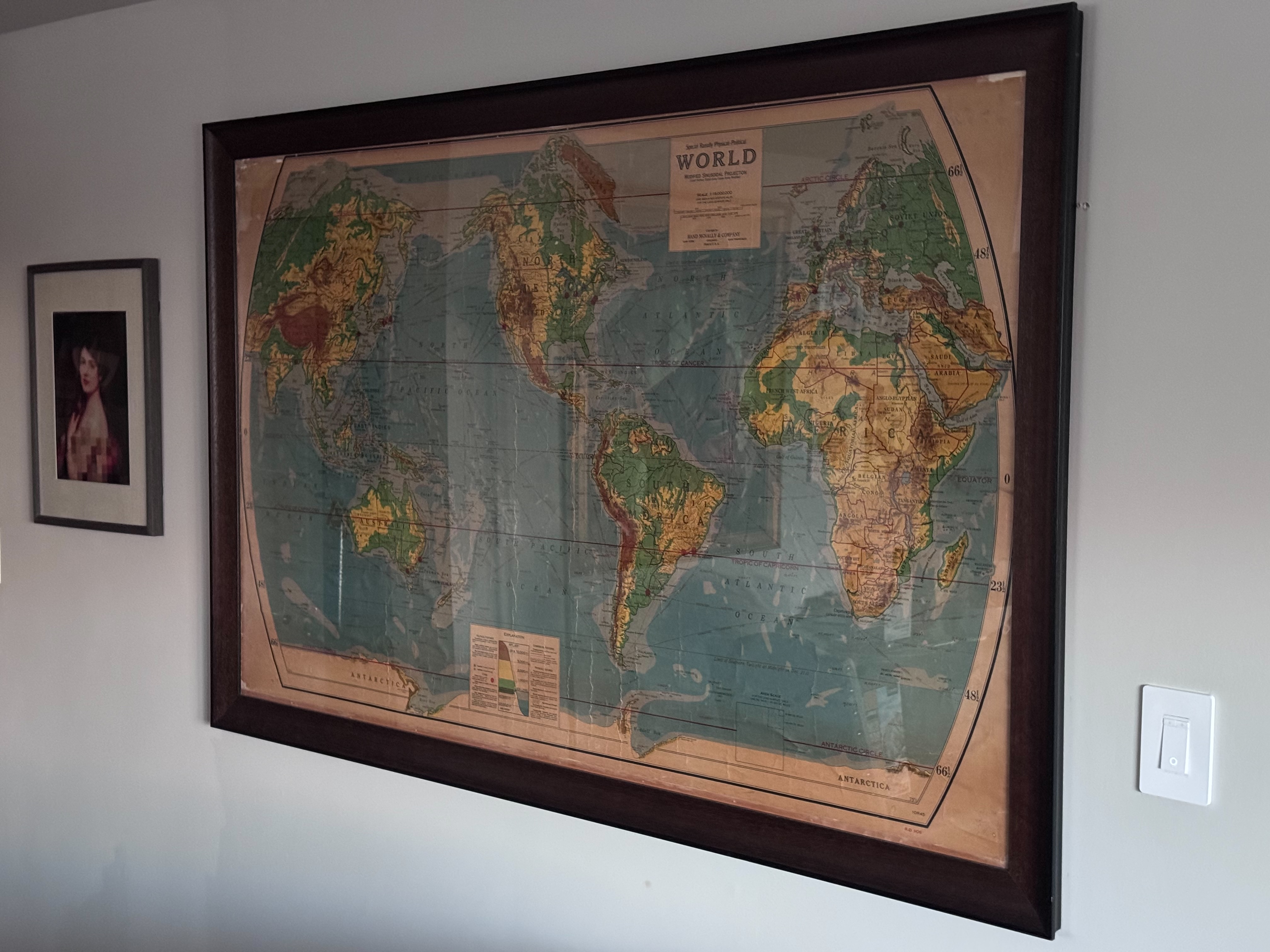
You noticed the old map on the wall, and the plaque next to it asked: "When was this map made?" Good question. The answer is hiding in plain sight — in the place names and political borders printed on the map itself. Countries have been renamed, borders redrawn, and empires dissolved. Each of these changes is a clue. Let's work through them, starting broad and narrowing in.
Narrowing It Down
The map shows the Soviet Union as a single country. The USSR was formed in 1922 and dissolved in 1991, so the map was made somewhere in that 70-year window.
The island we now know as Sri Lanka is labeled Ceylon here. It wasn't renamed Sri Lanka until 1972, trimming our window down.
Africa shows colonial territorial divisions rather than independent nations. 1960 was the "Year of Africa" when dozens of colonies gained independence, so this map predates that wave.
The Dutch colonial territories are labeled East Indies. They became Indonesia in 1945, though the old name lingered on maps into the early 1950s. We're getting close.
Siam was renamed Thailand in 1939, but after WWII it briefly reverted to Siam from 1945 to 1948. This map says Siam — so it's either very old, or it falls in that narrow post-war window.
The island is labeled Formosa(Taiwan). Formosa was the name under Japanese occupation, which ended in 1945. The parenthetical "Taiwan" signals this was made after Japan's surrender — the final piece of the puzzle.
So When Was It Made?
1946 or 1947
The two tightest clues — Siam and Formosa(Taiwan) — lock it down. "Siam" only appears on maps from before 1939 or during the brief 1945-1948 reversion. "Formosa(Taiwan)" only appears after Japan's 1945 surrender. The only overlap is 1945-1948.
Combined with the colonial African borders, the "East Indies" label, and Rand McNally's post-war wall map format, this map was almost certainly printed in 1946 or 1947 — a post-WWII edition reflecting the new world order while cartographic conventions were still catching up with political realities.
About the Map
This wall map was published by Rand McNally & Company using their distinctive Modified Sinusoidal Projection. This projection gives the map its characteristic curved appearance, which was a hallmark of Rand McNally's large wall maps in this era.
The yellowed paper and fold lines tell their own story — this map has been around for nearly 80 years, a wonderful artifact from the immediate post-WWII period when the world was being redrawn.